Cenozoic Reactivation
The Cenozoic era is characterised in SW England by reactivation of Variscan NW-SE faults in response to Atlantic extension and later compression from Alpine collision (Holloway and Chadwick, 1986). The most studied area for these fault movements is along the Sticklepath-Lustleigh Fault Zone although minor reactivation may have occurred along other NW-SE faults to the west.
Sinistral reactivation of the Sticklepath-Lustleigh Fault Zone resulted in up to 6 km of displacement and left-stepping fault systems formed the Bovey and Decoy basins (Holloway and Chadwick, 1986). The Petrockstow Basin, however, may have formed from right-stepping dextral reactivation (still producing net-extension) based on dextral positive flower structures identified by Bristow et al. (1992). It is more likely that dextral positive flower structures identified in the Petrockstow Basin relate to Miocene dextral transpression as observed in the Bovey Basin (Holloway and Chadwick, 1986). The apparent Palaeogene sinistral movements and Neogene dextral movements along the Sticklepath-Lustleigh Fault Zone are corroborated in the St George’s Channel by Ruffell and Carey (2001).
Lundy Island, located in the Bristol Channel has been interpreted to represent a further pull-apart basin structure (Arthur, 1989), which was intruded by the Lundy Granite and a basic dyke swarm mapped using magnetic surveying (Roberts and Smith, 1994). The Lundy Granite is Palaeocene (59.8 $\pm$ 0.4 to 58.4 $\pm$ 0.4 Ma; Charles et al., 2018) and forms part of the British Palaeogene Igneous Province. The granite and slightly later dyke swarm (c. 57.2 $\pm$ 0.5 Ma; Charles et al., 2018) may record the changing Palaeogene stress regime associated with the Sticklepath-Lustleigh Fault Zone (Roberts and Smith, 1994).
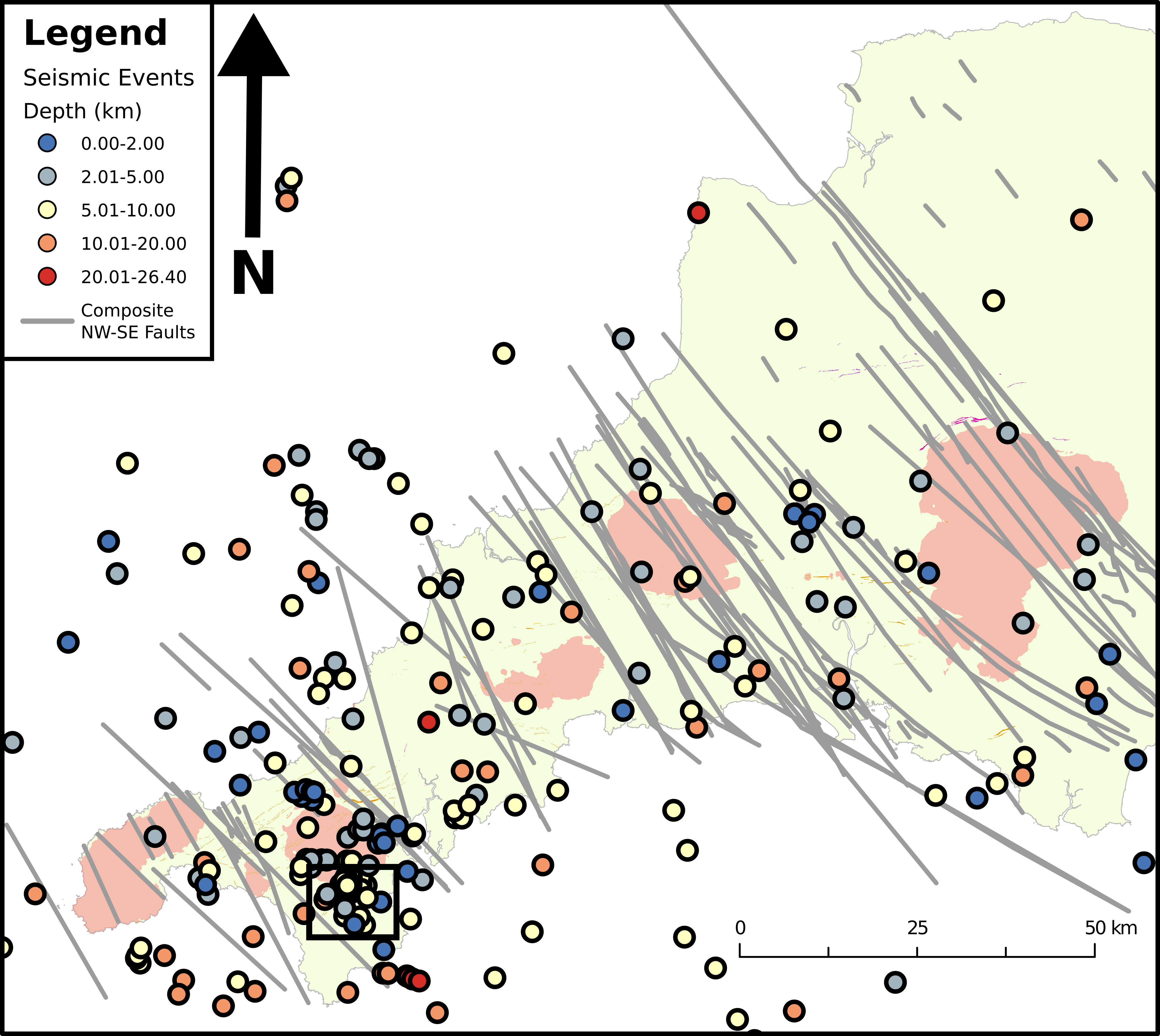
Whilst major strike-slip basin formation appears to be less prevalent further west, the Dutson Basin near Launceston, was identified by Freshney et al. (1982). Furthermore, Oligocene-Miocene sedimentary rocks have NW-SE palaeocurrent indicators (Walsh et al., 1987) which may indicate either a geomorphological control or an active fault control relating to NW-SE faults. Seismicity in the region still occurs and it is not uncommon for minor seismic events to be recorded in SW England by the British Geological Survey seismic network. These are illustrated in Figure 1 and show some coincidence with major NW-SE faults. A significant cluster also occur to the south of the Carnmenellis Granite at Constantine (square inset) and do not correlate with any mapped major regional faults. Many of these faults occur at shallow crustal depths (<10 km) which may indicate open fractures, a key target for in geothermal energy exploration.
References
Arthur, M.J., 1989. The Cenozoic evolution of the Lundy Pull-Apart Basin into the Lundy Rhomb Horst. Geological Magazine 126, 187–198. https://doi.org/10.1017/S0016756800006324
Bristow, C.M., Palmer, Q.G., Pirrie, D., 1992. Palaeogene basin development: new evidence from the southern Petrockstow Basin, Devon. Proceedings of the Ussher Society 8, 19–22.
Charles, J.-H., Whitehouse, M.J., Andersen, J.C.Ø., Shail, R.K., Searle, M.P., 2018. Age and petrogenesis of the Lundy granite: Paleocene intraplate peraluminous magmatism in the Bristol Channel, UK. Journal of the Geological Society 175, 44–59. https://doi.org/10.1144/jgs2017-023
Dearman, W.R., 1963. Wrench-faulting in Cornwall and south Devon. Proceedings of the Geologists’ Association 74, 265–287. https://doi.org/10.1016/S0016-7878(63)80023-1
Freshney, E.C., Edwards, R.A., Isaac, K.P., Witte, G., Wilkinson, G.C., Boulter, M.C., Bain, J.A., 1982. A Tertiary basin at Dutson, near Launceston, Cornwall, England. Proceedings of the Geologists’ Association 93, 395–402.
Holloway, S., Chadwick, R.A., 1986. The Sticklepath-Lustleigh fault zone: Tertiary sinistral reactivation of a Variscan dextral strike-slip fault. Journal of the Geological Society, London 143, 447–452.
Jackson, N.J., Willis-Richards, J., Manning, D.A.C., Sams, M.S., 1989. Evolution of the Cornubian ore field, Southwest England; Part II, Mineral deposits and ore-forming processes. Economic Geology 84, 1101–1133.
Roberts, C.L., Smith, S.G., 1994. A new magnetic survey of Lundy Island, Bristol Channel. Proceedings of the Ussher Society 8, 293–297.
Ruffell, A., Carey, P.F., 2001. The northwestwards continuation of the Sticklepath Fault: Bristol Channel, SW Wales, St. Georges Channel and Ireland. Geoscience in South-West England 10, 134–141.
Sanderson, D.J., Dearman, W.R., 1973. Structural zones of the Variscan fold belt in SW England, their location and development. Journal of the Geological Society, London 129, 527–536. https://doi.org/10.1144/gsjgs.129.5.0527
Scrivener, R.C., 2006. Cornubian granites and mineralization of SW England, in: Brenchley, P.J., Rawson, P.F. (Eds.), The Geology of England and Wales. The Geological Society, London, pp. 257–268.
Walsh, P.T., Atkinson, K., Boulter, M.C., Shakesby, R.A., 1987. The Oligocene and Miocene outliers of west Cornwall and their bearing on the geomorphological evolution of Oldland Britain. Philosophical Transactions of the Royal Society of London, Section A: Mathematical & Physical Sciences 323, 211–245. https://doi.org/10.1098/rsta.1987.0082
Chris Yeomans
Research Fellow
Research Fellow in deep geothermal energy exploration with interests in machine learning, mineral exploration and SW England geology.